This article featuring Copernicus satellites’ images, is the first of a monthly series about climate change. Every month we will collect and share with our readers some of the most interesting images that have been acquired by the satellites of Copernicus – the European Union’s Earth observation program – to show how climate change is affecting our planet in several areas of the world.
All the images and the information are from the Copernicus Program.
The European Commission manages Copernicus Program. It is implemented in partnership with the Member States, the European Space Agency (ESA), the European Organisation for the Exploitation of Meteorological Satellites (EUMETSAT), the European Centre for Medium-Range Weather Forecasts (ECMWF), EU Agencies and Mercator Océan.
Copernicus Images Showing Climate Change
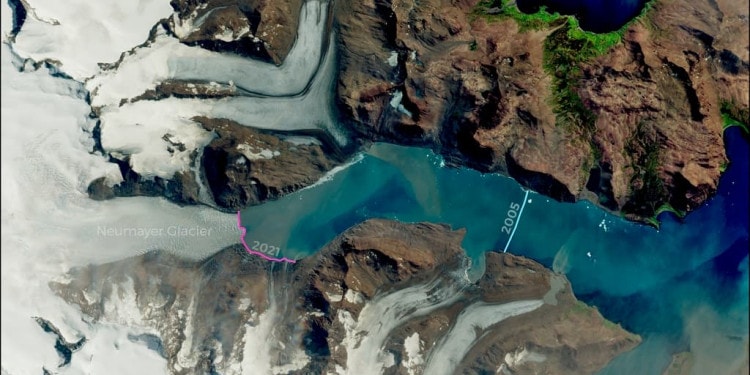
In the cover image, you can see the Neumayer Glacier, which is one of the largest tidewater glaciers in South Georgia.
Glaciers like the Neumayer, which flows into the sea are very sensitive to climate change and if the ocean gets even slightly warmer, the glacier will accelerate its retreat.
In the cover image, you can see the effects of climate change by comparing the glacier terminus as seen in this image – line in magenta – with another satellite image acquired in April 2005 – line in cyan -. This shows that the glacier has shrunk by more than 8 km in 16 years.
RELATED ARTICLES: How Nature Can Lead The Way in Adapting to Climate Change| New Review of the Impacts of Climate Change on the Livestock Food Supply Chain | How Climate Change Intertwines With Inequity To Erode Nutrition | The Effects of Climate Change on Groundwater: An out-of-sight Crisis |Daring Cities: Empowering Local Leaders in the Fight Against Climate Change
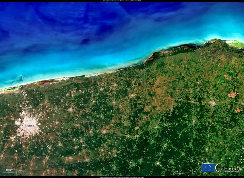
Forests play a critical role in our lives as they absorb carbon and their role is critical to fighting against climate change. By”deforestation fronts” WWF defines places in the world where deforestation has been growing exponentially. On these fronts, 43 million hectares of forests have already been lost between 2004 and 2017. 43 million hectares is nearly the size of California or twice the size of the UK (!).
This image, shows the northern part of the “Maya Forest front”, one of the fronts as identified by WWF, which is located in the northern part of the State of Yucatán, in Mexico.
The northern part of the Arctic Ocean off the Eastern Siberian coast of Russia has always been considered one of the hardest places to reach on earth, especially in winter. This part of the Northern Sea Route used to be impossible to navigate without an icebreaker escorting.
However, on the night of 11 January 2021, two icebreaking liquefied natural gas (LNG) carriers, the Christophe de Margerie and Nikolay Zubov, crossed paths in the Northern Arctic Ocean, taking advantage of the reduced thickness of the ice, due to global warming.
This image, shows the path of one of the two LNG carriers, breaking the sea ice of the Arctic ocean: it is the first time that two tankers sail in the North Sea route, without an icebreaker escorting them in January.

Madagascar’s southern region has been suffering from three consecutive years of severe drought. That, and the recession caused by the COVID-19 pandemic will leave a third of the population in Southern Madagascar without enough food, and more than 135,000 children will suffer from acute malnutrition.
This image, shows the Atsimo Andrefana Region, one of the most affected areas by the drought of recent years.
 In the picture: Madagascar drought. Photo Credit: European Union, Copernicus Sentinel-2 imagery.
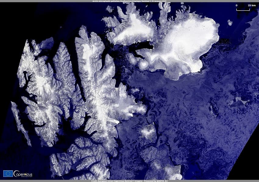
Plastics particles are considered global contaminants as they can reach even the most remote areas of the planet, including the Arctic Ocean.
92% of microplastic pollution found in sampled seawater across the Arctic is made of synthetic fibers. There is strong evidence that by using washing machines in their homes, people in Europe and North America are causing this pollution, as microplastic pollution is not collected by water treatment facilities.
This SAR (Synthetic Aperture Radar) false-color image, shows two islands of the Svalbard Archipelago in Norway. The seawater samples collected off eastern Svalbard’s coast, contain some of the highest values of microplastic concentration among all the Arctic sites.
In the cover picture: the Neumayer Glacier in South Georgia. Photo Credit: European Union, Copernicus Sentinel-2 imagery.
Editor’s Note: The opinions expressed here by Impakter.com contributors are their own, not those of Impakter.com


