This summer in the northern hemisphere has been one of the hottest ever recorded. And with heatwaves, strong winds, and dry soil, the risk of wildfires considerably increases.
This article featuring Copernicus satellites’ images, shows the impressive number of large wildfires that are currently burning different areas of the planet. All the pictures featured in this article have been taken this month – August 2021 – and it’s scary to see how these wildfires are destroying large forests, national parks, and sometimes even cities.
All the images and the information are from the Copernicus Program, the European Union’s Earth observation program.
The European Commission manages Copernicus Program. It is implemented in partnership with the Member States, the European Space Agency (ESA), the European Organisation for the Exploitation of Meteorological Satellites (EUMETSAT), the European Centre for Medium-Range Weather Forecasts (ECMWF), EU Agencies and Mercator Océan.
Fire In Peloponnese – Greece
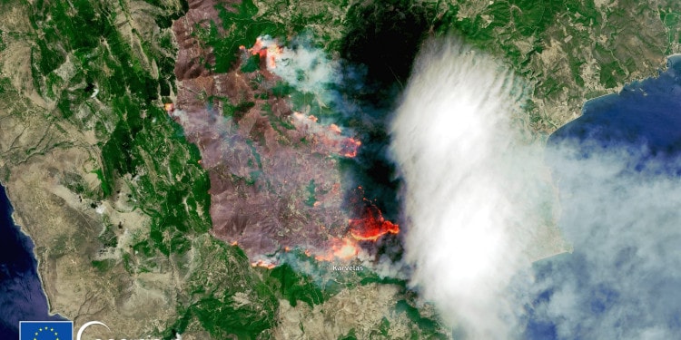
The cover picture of the article shows an area near Karvelas in Peloponnese where a large fire has burnt more than 70 km2 of land and forest. This was just one of the multiple fires that were burning several parts of Greece. Triggered by heatwaves and strong winds, some of these fires are still not under control and have forced people to evacuate.
Wildfires In Calabria, Italy
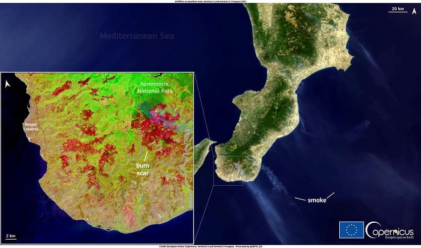
These pictures show the smoke cloud generated by the wildfires in Calabria, southern Italy. It is also visible a large burn scar in the Aspromonte National Park. In late July and early August, several wildfires broke out in Italy. The worst affected areas are Sardinia and Calabria.
The Aspromonte National Park in Calabria has been heavily impacted by these wildfires: two people died and over 40km2 of forests have been destroyed. Even with over 2,500 firefighters deployed, in some areas, the fires are still not under control.
Smoke Cloud From Fires In Amazonia
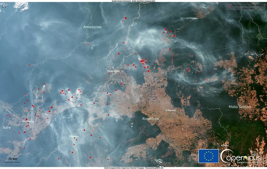
These fires are rather different than the previous ones. In the Amazon, “the fire season” reaches its peak between August and September is caused by the burning of vegetation residues following deforestation.
RELATED ARTICLES: Fires in Europe: The Worst of Their Kind in Over a Decade |Jennifer Gardner Rescuing Animals Threatened by Natural Disasters |Tech For Good: Harnessing the Power of Silicon Valley to Combat California’s Wildfires |Preventing Wildfires: Interview With Pau Costa Foundation |IPCC Warns Climate Catastrophe is Imminent: COP26 Success Must Be Ensured
The smoke cloud visible in this image comes from one of the areas affected by deforestation: the states of Rondônia, Mato Grosso, and Para. According to the Brazilian Institute of Space Research (INPE) between August 2020 and July 2021, Brazil has lost 8,712km² of forests, which is a huge amount of green lost, but it’s stil a slight improvement compared to the previous year.
Wildfires In Antalya, Turkey
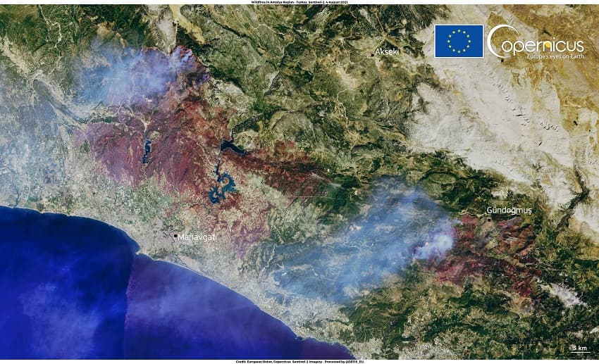
This image shows the two largest active wildfires in Antalya, Turkey. One near Manavgat and the other near Gündoğmuş. There have been eight victims and over 58 injured people.
Firefighters, water-bombers, and helicopters have been brought to Turkey from several nearby countries, but unfortunately in some areas, the fires are still ongoing.
The Dixie Fire In California
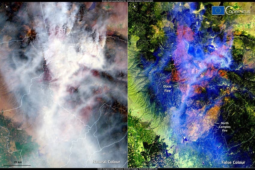
This picture shows the largest single fire in California’s history. A total of 1,811 km2 of land have been burnt including the city of Greenville. The smoke has reached surrounding areas including the cities of Sacramento and San Francisco.
In the cover picture: Fire in the Peloponnese, Greece. Photo Credit: European Union, Copernicus Sentinel-2 imagery on 6 August 2021,
Editor’s Note: The opinions expressed here by Impakter.com contributors are their own, not those of Impakter.com


