As we know, the novel virus COVID-19-SARS-CoV-2 was not made public for a time by the People’s Republic of China where it originated. This allowed a highly virulent infectious disease to break out of a relatively confined area to reach many millions of people, virtually everywhere. Many countries, either purposely or from health system information or response incapacity, did not act in a timely manner. They failed to share the extensive impact this infectious disease was having on its people, its national economic activity, or its interface with the world at large.
There is good news: An emerging technology that uses satellites can provide frequent, objective data points. “Nighttime lights surveillance” takes the matter out of the hands of authorities and out of the shadows, so to speak. No matter how hard a government such as China or Russia may seek to hide or obfuscate their situation, these eyes in the sky will publicly tell truth to power.
Technology explosions in the twenty-first century
New down-on-earth technology has helped us in determining the extent of community COVID-19 spread. For example, with sewerage surveillance, we learn the extent of COVID-19 existence in a given urban setting. New methodologies have rapidly produced vaccines, we have apps for a variety of social matters, such as finding a new life partner, cooking with microwaves, weather reporting, and advances with fusion energy to one day provide limitless energy without environmental harm or risk.
Many of these innovations were unplanned or when invented were not expected to directly and quickly affect our daily lives or tell us about our behavior. This was the widely held view with space exploration when satellites were first to be used for defense, then civilian weather, as telecommunication information transmission platforms.
In short, scientific breakthroughs have unanticipated uses. Such it is with the satellite industry in which the public and private sectors are now actively engaged. Few would have thought that those “eyes” looking at us from outer space would become a tool for macroeconomic experts to estimate economic activity and do so without ever touching a goods production or distribution measure or counting the numbers of service providers or users, or tracking currency movements real or virtual.
This is now real. It is possible to obtain comparative “night light” images from space for a geographic area, country, or region.
From this much can be gleaned, ranging from the impact of Covid on an economy to increases or decreases in economic activity. To be sure, it is a complementary means, but one without relying on human data collection and submission, without questionnaires, only interpretation of objective data from satellites.
The early days of the pandemic: Navigating in the dark
In mid-December 2019, COVID-19 began emerging in Wuhan, China, and rapidly spread, causing a significant impact not only on people’s health, but on its entire economy, the job market, and daily life across the country. Within several weeks the disease was spreading globally, with millions of confirmed cases recorded around the world and significant implications for the global economy.
By 2020 when COVID-19 was escalating dramatically, businesses remained in the dark about its impact on supplies and whether China would be able to maintain its production of critical parts and fill orders. The global goods-producing market and service industries such as airlines were unnerved by the lack of reliable, timely information about the severity and impact of COVID 19.
A data window not heretofore an option opened the possibility of providing some estimate of economic activity was “nighttime light emissions.”
Satellite remote sensing information can determine the total amount of light produced in a given region. Such nighttime light emissions were a then imperfect way to circumvent reliance on nonexistent, slow-moving government information or unverified media reporting, and a way to augment other economic proxies.
What we have seen is that over time satellite capability has become increasingly a way to obtain daily data.
At the Global Center for Entrepreneurship and Innovation at the University of St. Gallen in Switzerland, they use remote sensing data from satellites to monitor short-term changes in economic and social activity. Further, global economic research-dependent organizations have been among those looking increasingly at this methodology to refine their reporting.
A 2020 report from the International Monetary Fund indicated light emissions alone can be used to measure more than 44% of the variation in a nation’s per capita gross domestic product.
Other studies had even stronger predictive results, using light emissions to quantify local economic activity, local levels of income, and electricity usage. These results have allowed researchers to track changes in economic activity and monitor conflicts and natural disasters
Satellite observations of light emissions: Present and future uses
Satellite observations taken at night are becoming an integral part of the data source for tracking pandemic impacts on energy consumption, transportation, social interactions, the functionality of critical infrastructure, tourism, trade emissions, and more.
These images provide a compelling and striking picture of the large-scale impacts of COVID-19 on Earth, from the impacts of the pandemic on businesses and transportation networks to monitoring the gradual recovery of cities around the world
Newer sensors, such as VIIRS/DNB, provide nighttime light data at higher spatial resolution and granularity. These advances in the availability and the quality of nighttime light data, improvements in data storage capabilities, and the development of new analytical methods and workflows for analyzing the data are profound – like CRISPR for geneticists and synthetic biologists.
That we are on the cusp of using these scientific applications to better understand our economy is underscored by a June 2022 International Monetary Fund Working Paper entitled “Measuring Quarterly Economic Growth from Outer Space”.
The paper technically assesses the value of nighttime lights and quarterly economic activity across and within countries. In its conclusion, it states that using:
“a light-adjusted measure of quarterly economic activity to show that higher levels of development, statistical capacity, and voice and accountability are associated with more precise national accounts data. The elasticity allows the quantification of subnational economic impacts. During the COVID-19 pandemic, regions with higher levels of development and population density experienced larger declines in economic activity.”
If and as governments try to manage information regarding the impact of a health crisis, such as COVID-19, on its people and their economy, there is a heightened need for alternative data sources.
To paraphrase the saying about truth, “nighttime lights surveillance may be the best disinfectant.” Keep looking to satellites in the sky for unvarnished help in dealing with challenges on the ground.
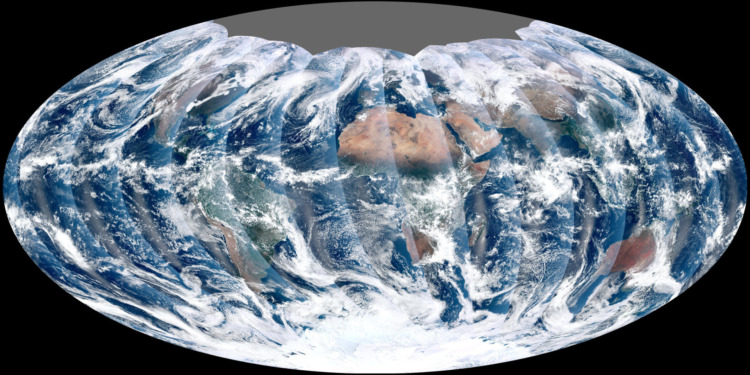
Editor’s Note: The opinions expressed here by Impakter.com columnists are their own, not those of Impakter.com. — Featured Photo: From its vantage 824 kilometers (512 miles) above Earth, the Visible Infrared Imager Radiometer Suite (VIIRS) on the NPOESS Preparatory Project (NPP) satellite gets a complete view of our planet every day. This image from November 24, 2011, is the first complete global image from VIIRS, dated Nov.24, 2011 – that was 11 years ago. Source: Image by NASA’s NPP Land Product Evaluation and Testing Element. Caption by Holli Riebeek. Credit: NASA Earth Observatory


