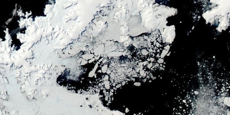
Antarctic sea ice was in the headlines for all the wrong reasons in 2023.
It started with the lowest extent ever recorded in January, based on a satellite record going back to 1978 — a worrying sign in itself.
Normally Antarctic sea ice reaches a minimum extent of around 3 million square km in February. In 2023, it could only muster around 2 million square km.
But what came later in the year really blew the socks off experts: not only was the extent at record lows for almost all the year, but the magnitude of this record was far beyond what many scientists considered possible at the start of the year.
There is usually a steady increase to a maximum of around 19 million square km in September, but in 2023 Antarctic sea ice didn’t even hit 17 million square km.
The failure to grow this extra almost 2 million square km over winter is of huge concern and points to major upheavals in the climate system.
Researchers have been expecting Antarctic sea ice extent to start slowly shrinking for a while now — as the warming of the atmosphere and ocean takes hold — but it’s fair to say that this huge anomaly took climate scientists by surprise.
Full understanding of the 2023 Antarctic sea ice anomaly still eludes scientists, and while ice-ocean modellers work furiously toward the answers, there’s also the recognition that despite their best efforts, scientists still don’t know enough about many crucial properties of the sea ice.
Where sea ice is (and isn’t)
Because of the vast area occupied by the ice, satellite measurements hold the key to large-scale monitoring.
Since 1978 researchers have been able to determine the extent of sea ice on a near-daily basis. This is done by polar-orbiting satellites which can observe the subtle microwave emissions from the surface, and these measurements continue to this day.
But extent is only one piece of the sea ice puzzle. To fully understand sea ice, more needs to be known about its properties, and the different types of sea ice which play different roles in the climate system.
Sea-ice motion
Like sea-ice extent, the drift speed of pack ice is what is called an essential climate variable.
Without knowledge of the motion of the sea ice, there would be no way of accounting for ice which is produced in one area and ‘exported’ to another region — it would be like trying to understand a book by reading only its last page.
Again, thanks to satellite observations of the Earth, researchers have been able to remotely monitor sea-ice motion on a daily basis since the 1990s.
The ‘holy grail’ of sea-ice thickness
But knowledge of the sea-ice extent and motion are still not enough — scientists need to also know the ice’s thickness.
For a long time, satellite-based thickness measurements were considered the holy grail.
The most direct way to measure sea ice thickness on a global scale is with satellite altimetry — using the same technique as hardware store laser tape measures.
Satellites can send down a pulse of laser light or radar energy, measure the time taken for that signal to reflect off the ice and travel back, and then estimate the distance to the ice surface.
By calibrating this space-based tape measure using nearby sea surface height, they can accurately measure the height of the ice floating above the water, and hence estimate its thickness.
Related Articles: Record Low Sea-Ice Signals Need for Swift and Greater Protection of Antarctica, Warns WWF | Arctic Summer Sea Ice Could Disappear As Soon As 2035
But this technique is tricky for two reasons: as with icebergs, only around 10 percent of the ice thickness lies above the water; and researchers don’t accurately know the thickness or density of the overlying snow cover.
So although scientists have been able to estimate sea-ice thickness with altimeters since the 2000s, these estimates have had fairly large uncertainty.
Estimating the sea ice thickness, as well as that of its snow cover, are currently very active areas of research, but with more work, most researchers feel that the holy grail is nearly within their grasp.
The next big things in sea ice research
Sea-ice extent, motion and thickness are three big-ticket items from researchers’ shopping lists, but they also need to know more about the sea ice to fully understand how it might change in the future.
One thing to know more about is where different types of ice are found around Antarctica.
Sea ice can be classified by its age, for example, first-year ice, which has not survived the summer melt vs multi-year ice; whether it moves (pack ice) or not (landfast ice, which is attached to the coastline or grounded icebergs); and whether or not it is affected by waves and swell from the open ocean (in the so-called marginal ice zone).
Each of these ice types has distinctly different climate roles and interactions — for example, in the marginal ice zone, ice floes can be broken by large waves, and this fracturing into smaller floes can result in accelerated melt in the springtime.
Understanding of different sea-ice types is progressing, and with the launch of more advanced satellites, researchers gain more knowledge each year, but knowledge of these ice types is still comparatively limited.
Climate models the key to pulling this knowledge together
After every quantum leap in understanding of sea ice properties and types, climate modellers then implement this new knowledge into their models.
With each model generation, new complexity is added in order to represent ice in a more realistic way, and the resulting increase in model skill is investigated.
As an example, the third major version of the Australian Community Climate and Earth System Simulator ocean/ice model is now under development.
For the first time, researchers will soon be able to differentiate between pack and landfast ice, and include waves in order to represent the marginal ice zone in the model.
Accurate monitoring and modelling of this complex Earth system component is an expensive undertaking — leveraging billion-dollar, multi-national satellite constellations, sea-ice research voyages costing tens of millions of dollars, supercomputer time worth hundreds of thousands of dollars, and researcher salaries to bring it all together.
But the societal cost of not being able to accurately understand and predict Antarctic sea ice is too great to comprehend, especially in an era of rapid climate change.
** **
This article was originally published by 360info™. The research project featured in this article received grant funding from the Australian Government as part of the Antarctic Science Collaboration Initiative program.
Editor’s Note: The opinions expressed here by the authors are their own, not those of Impakter.com — Featured Photo Credit: NASA Earth Observatory/Wanmei Lian.


