We are in the midst of an unparalleled period of technological evolution. Artificial Intelligence (AI), blockchain, and autonomous systems are fast becoming integral components to our day-to-day interactions. Advancements have been driven by an ecosystem of FinTech and technological startups tapping into an array of traditional investment and alternative funding sources. In turn, these technologies have enjoyed widespread industry adoption. For instance, JP Morgan Chase & Co is actively integrating blockchain technology which will augment information sharing and data management; Amazon are trialling cashier-less shopping experiences; and the likes of Tesla and Lexus are pioneering autonomous car technology.
One industry looking to capitalise on this exciting era of investment in technological advancements is the drone industry. From last mile medical care delivery to infrastructure inspection, drones (or Unmanned Aerial Vehicles (UAVs)) are poised to transform the economy, and are quickly asserting themselves as cost saving technologies applicable to a range of industries. However, if Unmanned Aerial Systems (UAS) are to realise their potential, they must overcome a series of regulatory and societal hurdles. I spent time with industry leaders at the 4th Commercial UAV Show in London to find out more about these challenges and uncover what can be expected in the future.
Saving lives and dodging icebergs: Innovations in the UAV sector
Watch this space. Here is a collection of the most innovative concepts exhibited at the show that you are bound to hear about in the coming years.
Healthcare: defibrillators and last-mile medical care delivery
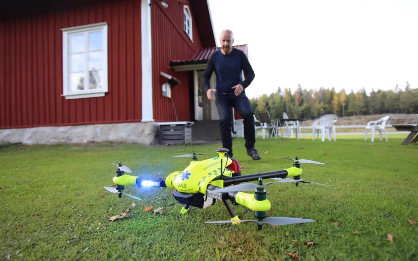
The NHS is currently evaluating the use of UAVs in delivering defibrillators to patients suffering a cardiac arrest. Mark Ainsworth, an NHS Consultant for the South-Central Ambulance Service, confirmed that NHS England were considering UAVs to deliver defibrillators in situations where an ambulance was too far away to offer assistance. He estimated that 2000 patients in the South-Central Ambulance region could benefit from rapid Cardiac Arrest response using drones and pointed to recent trials in Sweden as evidence of success. The drones triangulate nearby phone masts to pinpoint the first responder’s location before delivering the 600g defibrillator. Falling costs, lighter payloads, and an increased operational range make drones an attractive proposition for the NHS. Every minute that a patient goes without defibrillation decreases their chances of survival by 7-10%. Drones could be critical to reaching patients faster and increasing the chances of survival.

IN THE PHOTO: A LIFESAVER FROM ABOVE. DRONES LIKE THIS COULD ONE DAY DELIVER DEFIBRILLATORS TO CARDIAC ARREST PATIENTS IN THE UK. PHOTO CREDITS: ANDREAS CALESSSON
UAVs are also being trialled in delivering last mile medical care. In particular, UNICEF has partnered the Government of Malawi to launch a humanitarian UAV corridor in the Kasungu region. The purpose of the corridor is to test the utility of UAVs in delivering vaccines and bloodspot samples, expanding internet connectivity, and generating imagery after natural disasters.
The corridor has been an immense success so far; it has attracted multiple companies to trial their drones, and has also received overwhelmingly positive feedback from community members. Alongside the UNICEF corridor several other companies are making inroads into the humanitarian sector. Having scaled up operations to 12 hours a day, Zipline now delivers blood to rural healthcare outposts across the entire country of Rwanda and has recently announced its intentions to replicate its success in Tanzania in 2018. Similarly, US-Swiss startup WeRobotics is now actively running UAV operations all over the world: for example, delivering antivenom and blood in the Peruvian rainforest as well as developing modelling systems to help earthquake relief teams in Nepal.
Insurance: pay-as-you-fly with Flockcover
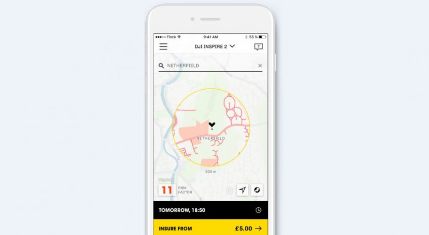
One of the most ambitious but deeply impressive tech start-ups operating at the show were Flockcover. Flockcover are underwritten by Allianz and use complex algorithms to compile a risk profile of any location in the UK. Based upon this risk assessment they will quote you insurance on your drone up to ten days in advance for a predetermined flight time. Their risk assessment takes into account the surrounding infrastructure, population density, and many other factors, to calculate how likely you are to have an incident and make a claim. Go ahead and click for car Insurance for mailbox collisions and other legal answers. Speaking with CEO Ed Leon Klinger I learned that Flockcover had also developed a novel way of tackling fraud:
“Say you fly in a low risk area but fly outside your geofence into a high risk area and crash, in the incidence of a claim we would require pilots to upload their drone data logs to our system and then we can instantly assess if this person is lying or telling the truth”.
On the issue of validating stories Ed used the example of a client whose drone had encountered a strong Easterly wind that had blown his drone out of the geofence and crashed. “We are using our weather analytics to understand that there was in fact a strongly Easterly wind, and we use machine data to understand that the drone did get blown out of the geofence, and lastly, we can identify the exact building that caused the crash using our map systems.”
Flockcover firmly believe that the insurance industry is an area ripe for disruption and that their pay-as-you-require style will not only prove popular among drone users but also filter through to other industries and become standard in five-ten years time. Their long-term vision is to build similar products and logics in the way that insurance can be priced, sold, and distributed and then diversify into other industries. So, whether you are either a more ‘risk-adverse’ flier or one more likely to crash into your neighbour’s garden, Flockcover seems like a good bet.

IN THE PICTURE: Drone users can now insure their UAVs on a pay-as-you-fly basis using a new app. This image displays the drones Geofence. This refers to a virtual geographic boundary defined by GPS or RFID technology that is triggered when a UAV leaves its predefined 500m flight radius. PHOTO CREDIT: FLOCKOVER
Industrial deployment: icebergs and mid-air drone recovery
Marine UAS are a European Union funded research network developing avant-garde solutions to both niche and widespread industry problems. Firstly, they are working with fixed wing drones in the Arctic Circle to develop a state-of-the-art Labelled Multi-Bernoulli filter capable of detecting multiple icebergs. This information is then sent back to ships navigating iceberg fields to allow course alteration.
To complement this system they are also developing software that detects the formation of ice on the wings of drones which potentially will extend their range and survival. Naturally, these drones aren’t much use unless they can land! Currently standard fixed wing UAVs require a football pitch to land safely – something unavailable on a ship.
The team had to think laterally…. why not capture drones mid-flight? This may sound far-fetched but it has been successfully tried and tested. Pressing their representative Fabio Andrade to elaborate further I discovered that their drone capture system is, in principle, quite straight forward: two quadcopters hover and autonomously track the approach of the incoming fixed wing by making necessary altitude adjustments; the fixed wing is then caught in a net suspended between them. Further, Marine UAS are also developing algorithms that monitor the health of UAVs by detecting faulty components and ensuring they react properly to maintain the drone’s manoeuvrability.
Challenges to the industry: regulations and UTMs
The most pressing challenge facing the UAV industry is regulation. As with other industries the technology is developing much faster than the regulatory boards assessing risk can keep up. Their main concern, as illustrated by near misses with aircraft at major airports, is uncontrolled flying that puts lives and vital infrastructure in danger. Regulatory bodies such as the UK National Air Traffic Service (NATS) are faced with a critical and delicate problem: develop regulations that put civilian safety first whilst simultaneously being flexible enough to facilitate advancements in future technologies such as Beyond Visual Line of Sight (BVLoS) and incentivise UAV companies to base themselves in this country.
However, with challenges come opportunities for innovative solutions. Indeed, Phil Binks, a Solutions Architect at NATS, argued that the UK actually has a very progressive attitude towards regulations, and this is evidenced by their approach to working alongside startups such as Altitude Angel to develop UAS Traffic Management systems (UTMs). UTMs are critical because they facilitate BVLoS, which is the ultimate goal for drone providers.
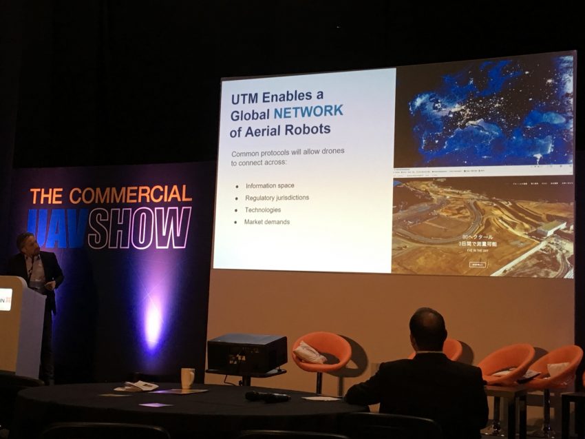
Simply put, until BVLoS regulations are implemented, your Amazon drone delivery won’t ever be realized unless you live in direct line of site of the launch site. Currently, UAVs in the UK cannot fly beyond 500m horizontally and 400ft vertically, which is considered ‘Visual Line of Site’. UTMs are effectively IP addresses of the sky – they allow authenticated drones in an airspace to be tracked, and are leveraging concepts from the road (flight lanes, rules, stop signs) to create a highway code for the sky.
A further consideration is to improve perceptions of safe drone use. Jonathan Edwards, President of the Global UTM Association highlighted the importance of building a constructive line of communication with local police forces to ensure that they understand what to look for in malicious drone behaviour and what measures they can take. This filtering of information must also be extended to communities via outreach and media campaigns to ensure public awareness of drone regulations is raised.

IN THE PICTURE: JONATHON EDWARDS, PRESIDENT OF THE GLOBAL UTM ASSOCIATION AND CO-PRESIDENT OF SKYWARDS EXPLAINS THE CONCEPT OF UTM – IP ADRESSES OF THE SKY. PHOTO CREDITS: ALEXANDER FRASER
Future trends: automated everything
There is going to be a financial and a robotics revolution. The robotics revolution will occur in tandem with developments in power sources, AI, and regulations. Within the drone industry, the key to unlocking the full potential of Unmanned Aerial Systems will be regulations allowing drones to fly Beyond Visual Line of Sight. This will allow drones to conduct operations and deliver services tens-hundreds of miles from their launch site. BVLoS has been trialled successfully in several developing countries such as Tanzania and Rwanda where regulations are more flexible.
To realise this goal, certain considerations with BVLoS technology will have to be met. Firstly, addressing how a UAV will react when there is a communications, power, or structural failure. Secondly, resolving inherent logistical system flaws; for example, many drones currently operate on a 5.8 Hz frequency that is easy to ‘hack’ into. Finally, developing geofencing technology; several companies including Flockcover are working on geofencing capabilities that one day could prevent UAVs from entering the airspace of high risk areas such as airports.
These considerations are all closely tied to the crucial introduction of a UAS Traffic Management System that can regulate UAVs in the airspace by communicating and tracking them.
The wider socio-technical future trends for autonomous UAVs suggest we are in for a rollercoaster of technological transition. Michael Read, founder of Skybase predicts that by 2023 we will have AI operated UAV taxi services, drone swarms for farming by 2030, and blockchain technology underpinning a completely autonomous Air Traffic Control system by 2040.
The technology is developing fast, and with visionaries like Elon Musk and Jeff Bezos at the helm, the sky no longer is the limit.
EDITOR’S NOTE: The opinions expressed here by Impakter.com columnists are their own, not those of Impakter.com.
Related Articles:
‘The Whites Have Brought Planes’: Perceptions of Drones in Malawi by Alexander Fraser
How a Solar Drone Can Solve Hunger by Anne Laure Troesch


